

INDIAN BURIAL GROUNDS UNEARTHED
The site on which Aaron made his new home was witness to some fascinating history prior to his arrival. Besides the exploration and immigration periods of the 1800s, the land saw centuries of Indian occupation stretching back into antiquity. Artifacts have been discovered on the site, which is located on present-day Turner Ranch in Victorville, about one-half mile downstream of the lower narrows bridge. On one occasion the unearthing of burial grounds nearly sent a man to jail.
The incident over the uncovered graves began early Wednesday morning, November 27, 1940, when Frank Turner sent a farm hand to plow some virgin land on his ranch. The area he had selected was near some sandhills, a distance away from the lowland previously cultivated in the overflow of the Mojave River.
Frank's daughter, Frances, was tagging along behind the plow, playing in the furrows, when what looked like a gray rock was thrown into her path. Stooping down to inspect it more closely, she found that it was not a rock at all, but a human skull. As it turned out, it was one of many human bones exposed by the plow.
Frank called the Sheriff's Office and the next day deputies Robert White and Carl McNew were on hand to investigate. Newspaper publisher J. E. Barry was present as well, and he wrote an article which appeared in the San Bernardino Daily Sun the following day. "Five skeletons were dug from a desert grave," said Barry, "on the...Turner Ranch north of Victorville. Each of the skeletons was in a sitting position facing the Mojave River." After describing the area of the find, Barry concluded:
Experts are of the opinion that the skeletons are those of pioneers who traveled the old Mormon trail....They pointed out that the teeth of the two children, two men and a woman, were free of any indication of dental care, and in a perfect state of preservation. Their chief concern was an explanation for the odd positions in which the family was found to have been buried. |
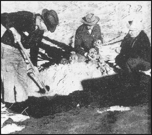
Since no other individuals are mentioned in the article as being in attendance, and as the photo accompanying the article shows only the two deputies and the newspaperman, it may be surmised that these are the experts to whom Barry refers. Why the "experts" did not even consider the possibility that these were Indian remains is hard to understand. And in light of Frank Turner's description of the site years later to local historian Helen Graves, it becomes even more imponderable.
According to Frank, the bodies were in a crouching or kneeling position, all facing the river, and all had beads around their necks. There were 26 or 27 bodies altogether, but five or six were in better condition than the others. The remains had been cremated, and buried in the graves with them were large rocks (Helen Graves thought these may have been heated and used for the cremation process).
Not only were the deputies slow in identifying who was buried in the graves, but they also decided to charge Frank with the crime of desecrating a cemetery. They were ready to take him in, but after contacting the District Attorney, Jerome Cavanaugh, and Judge Allison, Frank was assured he would not be arrested if he reburied the skeletons.
His troubles were still not over. Barry's article had created much public interest and the next weekend there were so many people at the ranch that Frank could not even get into his own driveway. He told Helen Graves he was accused of being a publicity seeker. The last indignity over this incident was that some said "there was a trough full of artifacts" which had disappeared, strongly hinting that he was responsible. In truth, these artifacts wound up in the San Bernardino County Museum.
THE "OLD ONES"
Frank would have saved himself some trouble with the authorities had he known about a visit to the ranch some eleven years earlier by archaeologist Arthur Woodward, then with the Los Angeles Exposition Museum. Early in 1929 Woodward was shown the ranch by John Calvin Turner, whose father, Robert Turner, had purchased the ranch in 1883.On that occasion pottery was discovered -- pottery which had decorations similar to those found at the "lost cities" of Nevada. At a later luncheon with the Lions Club, Woodward stated, "...the Nevada ruins are very old, perhaps antedating those of the cliff dwellers of Arizona and New Mexico." He said that bits of the earthenware and beads at the Turner Ranch site seemed to be dated at the same age as the Nevada civilization.
Artifacts from more recent habitation were also noticed, but Woodward said the earlier objects were quite old, perhaps thousands of years. The Indian graves were found during the 1929 trip, and were located "on ruins which are much older [than the Spanish period]. The position and condition of various articles found indicate a great lapse of time between the deposits."
In 1950 newspaperman William Caruthers wrote of his desert experiences, and included some observations on the Indian burial practices. He reported that he learned of a burial place for a race of Indians antedating the Paiutes and Shoshones. "They buried their dead in a crouching position on their knees, elbows bent, hands at their ears." So these were the "Old Ones," and there is little known to this day of these ancients.

TOPIABIT RANCHERIA
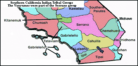
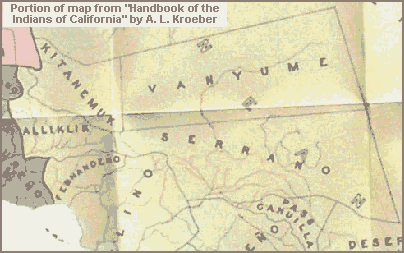
The site of Lane's way station was also the home of a more recent race of Indians, those who were here at the time the Spanish arrived. The San Bernardino County Museum Archaeological Site No. 88, besides being referred to by recent names such as Turner Springs Ranch and Adelanto Springs, is also designated as being the location of Topiabit (or Topipabit) Rancheria, which is described as a permanent village of Serrano-Vanyume Indians occupied in the last 1,000 years.
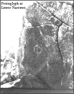
According to the Museum, the site is on the hills of sand above and north (the actual direction is south) of the ranch building. Flattened places on the hills suggested circular huts were present at one time. The Museum believes there were approximately 25 skeletons uncovered and also notes the cremations. The artifacts recovered included shell pendants and beads, bone awls, metates, manos, a clay pipe, a small mortar, a bone whistle, an abalone shell, and an arrow straightener. Some of the artifacts were from outside the area, leading Museum archaeologists to conclude that trade with other regions took place.
THE MOHAVE INDIAN TRAIL
Topiabit Rancheria was located on an ancient Indian trail used by the Mohave and Chemehuevi Indians from the Colorado River area on their trips to conduct trade with others along the Pacific Coast. The first European to learn of the trail was Father Francisco Garces in 1776. Pedro Fages had entered the area four years earlier while chasing Indians who had run away from the Mission San Diego, but it was Garces who first used the old Indian route across the desert.
The Mohave Indian Trail, as it was later known, utilized the scant water resources available in the desert, and without knowledge of its route, a trip across the eastern Mojave would have been hopeless. Coming from the Colorado River, the trail connected various springs until it reached the Mojave River, at which point it continued up-river to Sawpit Canyon and thence over the mountain range. It remained an important trade route for the Indians for 75 years after Garces learned of its existence, and it was also used by the Spanish for missionary purposes and for military expeditions against the Indians.
EXPEDITION OF FATHER NUEZ
One such military expedition actually refers to the village of Topipabit. In 1819 Lieutenant Gabriel Moraga and 55 men were sent to punish the Mohave Indians, who were reported to have killed some Spanish soldiers. Father Joaquin Pasqual Nuez accompanied the soldiers and kept a diary. On November 25th the expedition camped at a village called Guapiabit (Las Flores Ranch in Summit Valley), where they suffered "a painful night because of the excessive cold."
After spending another day at Guapiabit to rest up, the group traveled to Atongaibit (Hesperia). While resting there, a squad continued on about a league and a half to the upper narrows in what is now Victorville and discovered where the Mohaves had killed seven Christian Indians and an unspecified number of "pagans." The following day was Sunday, and Father Nuez conducted Mass and a funeral service:
I blessed a large cross which all the company venerated with devotion and tenderness, and immediately celebrated the Holy Sacrifice of the Mass and preached a sermon suited to the day. The Holy Sacrifice being finished, I ordered them to bring the bones and skulls of the Christians. They deposited them in the capilla with two candles burning. In the afternoon, all marching in procession, carrying in front the large blessed Cross, and behind the remains of the neophytes, while I was singing the funeral service, we arrived at the same place where the bodies had been burned. I ordered a deep pit dug, blessed the sepulchur [sic], and buried them at the foot of the Cross which we planted there. |
The next day, November 29th, they resumed the chase, and when they arrived at Topiabit they found the Indians were gone, apparently having fled before the onslaught of the Mohave war party:
At seven o'clock in the morning the Expedition set out from Las Animas benditas (the Blessed Souls of Atongaibit). About eight leagues (from our starting place) is the Rancheria of Topipabit without any inhabitant. I named it the Sweetest Name of Jesus of Topipabit. In about a league more we encountered the bones of pagan Indians, and farther on, the skulls and the bones of three children. At about three leagues distance from Topipabit is the Rancheria of Cacaumeat, called by us San Hilario, which name the Commander of the Expedition assigned it three years ago. All the night there were dense clouds threatening rain. |
The members of the expedition continued on down the Mojave, discovering more Indian remains, but they were ultimately unsuccessful in their mission due to the fatigue of their horses. All of these slain tribesmen meant quite a disaster for the local Vanyumes; never very numerous, they were no match for the fierce, warlike Mohaves.
JEDEDIAH SMITH CROSSES DESERT
In an expedition in 1826, now famous as the first overland trip from the American frontier to the California coast, trapper Jedediah Smith traveled through the Mojave Desert. The journey brought him and his companions up the Mojave River and past the Topiabit site.
Surprisingly, this prodigious feat began simply as a search for beaver that originated in the Great Salt Lake region following the 1826 rendezvous of fur trappers in Cache Valley. Smith and about fifteen others explored the southern Utah area, arriving at the Virgin River in September. They followed the Virgin to its confluence with the Colorado River, and then continued on down the Colorado for four days until they reached the Mohave Villages.
By this time their stock was jaded and supplies were running low. Smith was told the California missions were not far off, so with two mission runaways as guides, they set off for the coast, and for the first time the important route through the arid desert, with its precious watering spots, was revealed to American fur trappers.
Smith and his party reached the vicinity of Victorville in November. Their Indian guides, identified by Smith as "Wanyumas" (Vanyumes), both lived in the area, and they took the trappers to an Indian lodge located in a spot with "groves of Cotton wood and in places Sugar Cane and grass," a description that fits several places along the river, including Topiabit. The Indians at the encampment, whom Smith noted were not very numerous, shared what food they had with the visitors and treated them well.
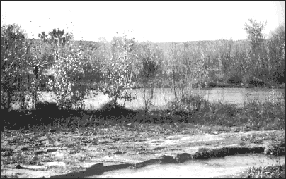
The trappers stayed the night at the lodge, and the next day they continued on their journey along the Mohave Indian Trail. The knowledge of this trail presented new opportunities for trade, and the next year, when Jedediah Smith left the rendezvous in Bear Lake, Utah, he made a return trip through the Mojave using the same route.
WILLIAM WOLFSKILL AND THE SPANISH TRAIL
Other American trappers also began using the desert route during the late 1820s, launching their business trips to California from the Mexican town of Santa Fe, now in the state of New Mexico. However, it was an 1830 expedition led by William Wolfskill that was to have a major impact on the desert area, for in that year Wolfskill pioneered the famous Spanish Trail between Santa Fe and Los Angeles.
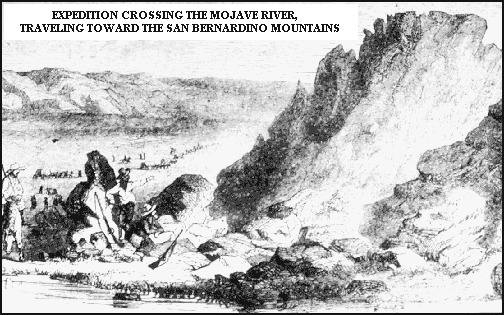
This route opened the way for an annual caravan that grew to become a significant factor in the commercial histories of these two communities. One of the improvements of the new route was that it veered off from the old Indian trail and crossed the Mojave River at a point below the lower narrows in present-day Victorville, and then headed southwest straight towards Cajon Pass. This shortcut, which saved several hours' travel time for the caravans, routed all the traffic past the Topiabit site and became known as the "upper crossing." Many years later it would be called Lane's Crossing.
JOHN C. FREMONT EXPEDITION
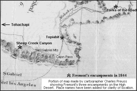
In 1844 the famous "pathmarker," John C. Fremont, came into the Mojave Desert from the Tehachapi Mountains on the second of his several expeditions through the West. While still in the Tehachapis, a San Fernando Mission Indian rode into camp one day and offered to conduct Fremont and his men to an old Indian route that led to the Spanish Trail.
Upon finding the Indian trail, which Fremont said was almost imperceptible from lack of use, the guide followed it for a few miles before halting to point out a black butte at the base of the mountains where water was to be found. Pointing at the trail, he said, "aqui es camino, no se pierde -- va siempre" (Here is the road, you cannot lose it -- it goes forever). The guide then left them, heading south to his home in San Fernando.
The trail passed "close along the mountain," at the northerly foot of the San Gabriels. Fremont made camp at Big Rock Creek, where there was water and grass in abundance. On April 19th, the expedition traveled another fifteen miles and made camp at Sheep Creek, but at this site, to Fremont's disappointment, "there was nothing but rock and sand." The following day, the party reached the Spanish Trail, and Fremont expressed their elation over finally being able to head homeward:
After a difficult march of 18 miles, a general shout announced that we had struck the great object of our search -- THE SPANISH TRAIL -- which here was running directly north. The road itself, and its course, were equally happy discoveries to us. Since the middle of December we had continually been forced south by mountains and by deserts....The course of the road, therefore, was what we wanted; and, once more, we felt like going homewards. A road to travel on, and the right course to go, were joyful consolations to us; and our animals enjoyed the beaten track like ourselves. Relieved from the rocks and brush, our wild mules started off at a rapid rate, and in 15 miles we reached a considerable river, timbered with cottonwood and willow, where we found a bottom of tolerable grass. |
The travelers had reached the Mojave River at the upper crossing. Fremont made no mention of an Indian settlement at the crossing, nor was there any noted by those to come later. The Indians' departure very likely was due to the Santa Fe traders, many of whom badly abused the native inhabitants. The Indians quickly learned to avoid the caravans, and since Topiabit was directly in their path, it is no wonder it was abandoned.
After resting for a day, Fremont continued down the river, following the encampments of the Santa Fe caravans:
A clear bold stream, 60 feet wide and several feet deep, had a strange appearance, running between perfectly naked banks of sand. The eye, however, is somewhat relieved by willows, and the beautiful green of the sweet cottonwoods with which it is well wooded. As we followed its course, the river, instead of growing constantly larger, gradually dwindled away, as it was absorbed by the sand. We were now careful to take the old camping places of the annual Santa Fe caravans, which, luckily for us, had not yet made their yearly passage. A drove of several thousand horses and mules would entirely have swept away the scanty grass at the watering places, and we should have been obliged to leave the road to obtain subsistence for our animals. After riding 20 miles in a northeasterly direction, we found an old encampment, where we halted. |
This encampment was later a way station called the Cottonwoods. On April 23rd the party made a long march of 33 miles, arriving at the Junction (later Forks of the Road), the point at which the trail left the river in a northeasterly direction. The next day they continued along the river for another eight miles and encamped for the night. Upon resuming the trek, Fremont stated, "We left the river abruptly, and, turning to the north, regained in a few miles the main trail, (which had left the river sooner than ourselves) and continued our way...."
PRATT PARTY LOSES WAY
Despite the description by Fremont of a well-beaten road, it was still possible to lose one's way through the desert, as happened to Orville Pratt on his trip to California from Utah in 1848. Pratt recorded the incident in a diary which was the first day-to-day account of travels on the Spanish Trail. He and his party, already spent from days of grueling travel across the desert, had just left Bitter Springs when they became lost:
Wednesday Oct 18th 1848 Left camp this morning the sun about an hour high under the impression that the next water was only 15 m. off. Soon after leaving camp we found ourselves off the trail and lost! The sun soon became severely hot, the sand deep, and from the weak condition of the animals they soon began to fail. No water or grass in prospect -- the men suffering from thirst -- mules giving out by the way, & our provisions short -- all united to give me one of the severest trials of my life. We kept on until about 2 oclock in the morning, & between that and daylight the men all got into camp. Could find no water. Daylight came & the men were sent in all directions but no water still! Travelled full 50 m. this day & camped in a dry arroyo. |
The party had reached the Mojave River, but as it so often happens, the river was dry. A later diarist wrote, "This stream...sinks and rises, resembling the 'little joker' in the hand of the thimblerigger, 'now you see it and now you don't.' Our guide informs us when he last passed here the stream was entirely lost, sometimes for a distance of 8 or 10 miles."
This is where desert way stations, with their supplies of water and provisions, would prove so useful in later years. On Thursday, October 19, 1848, exhausted and miserable, Pratt and his companions finally located water:
In camp which we made last night about 2 oclock. No water during the early part of the day, but finally found some. And greater joy I never felt at any time in my existence. And although without much of anything to eat the men seemed to forget all their troubles! Never until now have I really known what suffering is. My feet are blistered from walking full 30 miles yesterday over the burning sand & flint rocks. Boots are all worn out -- Coat and pants [tattered] from riding 2 m. through the muskeet -- shirt filthy with five weeks constant wear in the dirt -- & to complete the compliment of misery (as if a burning sun & hard riding by day, laying upon the ground between horse blankets at night, to say nothing of the food, not sufficient) in addition to all else, my body is literally alive with vermin! |
Many desert travelers felt the same conflicting emotions expressed by Pratt: great joy in finding water at the Mojave River and knowing they were going to survive, tempered by their miserable condition after the terrible journey across the desert.
|
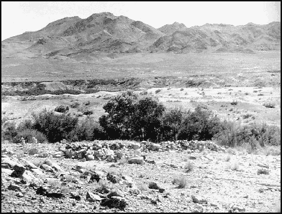
TRAVELERS ON THE SPANISH TRAIL ENDURED MILES OF RUGGED AND DESOLATE COUNTRY, RELIEVED NOW AND THEN BY STOPOVERS SUCH AS THIS OASIS OF RESTING SPRINGS |
THE SALT LAKE ROAD
During the next year the number of settlers coming into California increased, and the road across the Mojave began to take on a new character. By 1850 it had been adapted to wagon use, and when the Mormons came to the area from Utah the following year and established a colony in San Bernardino, the road became a major immigrant route. Not long afterwards freighters began using the route to haul supplies to interior territories, first to Utah along the Salt Lake Road, and then to the mining ventures in the Mojave Desert, Arizona, Nevada, and ultimately Idaho and Montana.
The existence of the Salt Lake Road by this time had become well known, but travel on it was still hazardous. The main dangers were the scarcity of water and provisions, and lack of forage for the stock. One large party could pretty well deplete a desert water hole; it could take days or weeks for the slow seeps to refill it, and a full season could pass before the grasses were replenished.
Also, Indians preyed upon the travelers on the road. A well-guarded group was usually in little danger from attack, but stray stock was at risk, and grief befell many a lone wayfarer or mail carrier.
By the mid-1850s mail service had been established on a regular basis along the Salt Lake Road. The mail carriers were the first to use the road year-round, the immigrant and freight trains coming through largely in the fall. The service was provided both through the official United States Mail, which was contracted to the lowest bidder, and by individual Mormons who carried mail back and forth while on business trips.
Express companies, including such famous names as Wells Fargo and Adams & Co., also began using the Salt Lake route. Thus another group was added to the growing number of travelers on the road along the Mojave River, but the amount of traffic on the desert was not yet sufficient to make permanent way stations profitable.

MORMONS IN A STATE OF REBELLION
In late 1857, the year Aaron Lane came to San Bernardino, a series of incidents occurred in Utah, some quite tragic, which were to have an impact on the development of the desert and all of San Bernardino County. Non-Mormon federal appointees in Utah had reported to Washington that their orders were being ignored and that the Mormons were in a state of rebellion against the laws and authority of the United States.
These reports were given credence, and Alfred Cummings was appointed to replace Mormon leader Brigham Young as governor. Cummings was to proceed to Utah accompanied by an army under the command of Colonel Albert Sidney Johnston. Word reached the Mormons in late July, 1857, that an army had been ordered to Utah to put down the rebellion.
The immediate response of the Mormons was to call on their militia, the Nauvoo Legion, to prepare for battle. Word went out in August that not one kernel of grain was to be sold to any non-Mormon merchant or "sojourner" in Utah; trading with emigrants traveling through the area was considered tantamount to aiding the enemy. Speeches became increasingly inflammatory as preparations were made to repel the oncoming government troops.
Mormon George A. Smith was sent to the southern towns in Utah to deliver military orders and instruct the populace. His preaching was so fiery that it raised the emotions of the citizens to a fever pitch.
In the meantime, Brigham Young met with twelve Indian chiefs from the southern region of the state, presumably to coordinate their support in the upcoming war. Into this climate came a wagon train of California-bound emigrants, which was later identified as the Fancher train, named after one of its leaders.
In mid-September, near a place called Mountain Meadows, all of the adults and older children of the Fancher train, numbering 118 in all, were killed by Mormons from the Cedar City area with the aid of their Indian allies. Only infants considered too young to testify against the murderers were spared.
Word of the massacre reached the Mormon Colony in San Bernardino on October 1st with the arrival of two Mormon freighters, Sidney Tanner and William Mathews, who had passed near the site the day the tragedy occurred. The news first appeared in the Los Angeles Star in the October 3, 1857, issue. Star editor Henry Hamilton, an admirer of the qualities of the San Bernardino Mormons with whom he was familiar, at first refused to believe that Mormons had anything to do with it.
However, when the truth of the atrocity became known, he joined with the rest of the community in calling for justice, although he still distinguished between the vast majority of decent, industrious people he had come to know and the perpetrators of a horrible mass murder. This incident, which became known as the Mountain Meadows Massacre, inflamed the citizens of California, and adversely affected the attitude of the military towards the Mormon community as a whole for years to come.
MORMONS RECALLED TO UTAH
Late in November of 1857 it was reported that there was a "general movement" of Mormons out of San Bernardino, departing for Salt Lake City. Henry Hamilton professed that he did not know why they were leaving, but knew "them to be a peaceable, industrious, and law-abiding community." Hamilton shortly learned they had been called back to Utah.
In a letter dated October 11th and received in San Bernardino on the 30th, Brigham Young thanked local leader William J. Cox for sending animals, teams, arms and ammunition, and then advised him that, in light of the situation, it would be best if the faithful returned to Utah immediately:
...the time appears to be near at hand when you will either have to abandon your faith or your present locality and escape to Utah....San Bernardino has a warm climate and it is highly probable that it may soon become altogether too warm for the residence of Saints, for this reason it is certainly advisable and my counsel that all in your place and region who desire to live as becometh Saints should use all diligence to make their way into Utah.... |
Mormon historians state that Young actually had planned for some time to recall the faithful from the San Bernardino colony because of dissension among the growing factions in the community, and the events of the fall simply sped things along.
On December 26th the Star reported that approximately 1200 people had heeded the call; 250 wagons had already departed town, and another 30 to 50 families were preparing to do the same. The bitterness of at least one departing Mormon is expressed in a letter he posted from Cajon Pass, in which he said that in his six and one-half years in the state, he had met friends, but "comparatively few, compared with the...hosts of bigoted, selfish, ignorant, and blood-thirsty wretches," and he wished sudden destruction on the state, condemning it "to the curses of Almighty Godžto famine, drought, war, and earthquakes."
There was a large number of Mormons in the colony who were not nearly as anxious to leave the state, and many of them determined not to return to Utah. Not only was the town split in two, but also many families were unable to agree amongst themselves on whether or not to stay, and some of them were divided permanently.
The Mormons said of those who stayed behind that they had abandoned the Church. But to those Latter-day Saints who had remained in San Bernardino, many of whom had followed their leaders all around the country -- some of them for decades -- it must have seemed that the Church instead had abandoned them.
MORMON EXODUS STALLS ON THE MOJAVE
By the middle of January there was a large encampment along the Mojave River consisting of 100 wagons. The pace of the departure had been deliberately slowed because of the "great destitution" in Salt Lake City due to the lack of supplies. The emigrants on the Mojave unselfishly sent their own supplies to Utah to relieve the suffering of their brethren there.
Amasa Lyman, previously a co-leader of the Mormon Colony, was at the river encampment buying supplies, through intermediaries, from his former townsmen. Meanwhile, camp life on the river was taking on the aspects of a settlement, what with the large number of marriages and births occurring as the Mormons patiently waited to continue their exodus.
Johnston's army had reached Utah in November 1857, rather late in the year to begin a campaign in a country known for its frigid weather. As the Army neared Salt Lake City, Colonel Johnston decided to encamp for the winter, a decision that allowed time for cooler heads to prevail and attempt to defuse the situation through peaceful means. Skillful negotiations between the Mormons and the U. S. Government prevented a continuation of hostilities, and by June 1858, the threat of war had ended.
A SECOND BATTLE FRONT
However, throughout the winter of 1857-58, even though negotiations had begun, war still looked imminent. During this period, the Star had urged that a second front be established using the Salt Lake Road. To assist the military, on December 19, 1857, the paper published a detailed description of the route, which was taken from notes made by freighter W. T. B. Sanford during an 1855 journey to Salt Lake City. In its January 9th issue, the Star called for a speedy end to the rebellion by marching troops into Utah from California, and the following week it quoted New York newspapers advocating the same strategy.
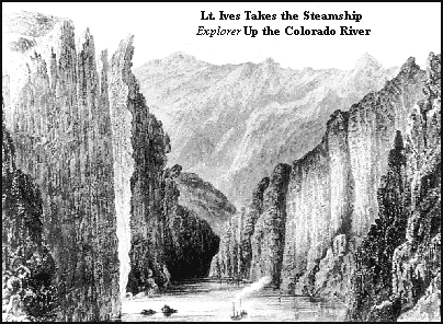
Coincidentally, at the same time the Star was urging a western assault, the government sent Lieutenant Joseph C. Ives, in command of the steamer Explorer, to investigate the navigability of the Colorado River in order to determine whether an army, or at least military supplies, could reach Utah by this route. Just prior to Ives' expedition, the privately-owned steamer General Jesup, with a squad of soldiers from Fort Yuma aboard, had made an exploratory trip up the river. Both expeditions reported that Mormons had been amongst the Mohaves, and had poisoned relations with the Indians, who were already nervous about the white man and suspicious of his intentions.
TROUBLE AT THE MOHAVE VILLAGES
Dennis G. Casebier, in The Mojave Road, states that the fear planted in the minds of the Mohaves -- that whites were going to come and take their land away from them -- may have led to their August 1858 attack on an immigrant train near the Mohave Villages on the Colorado River. At least eight members of the party were killed, with another two dozen wounded, and nearly all of their stock was lost.
As a result of this incident the military was brought into the desert, which would have long lasting effects: the permanent Army post of Fort Mojave would be installed at Beale's Crossing on the Colorado River, and to supply the fort, an overland route, called the Mojave Road, would be established through the desert.
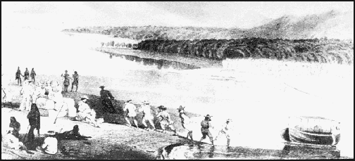
The first news of the attack was conveyed by a stage that arrived in Stockton from Kansas City in November. Colonel William Hoffman of the 6th U. S. Infantry was sent with an escort of 50 troops on a reconnaissance to the Mohave Villages.
The contingent left Martin's Ranch in Cajon Pass on December 28, 1858, and reached the Colorado River a week and a half later. The route Hoffman had traveled across the desert was the old Indian trail, and even though he reported to his superiors that it was impracticable for supply purposes, it was that route that became the alignment of the Mojave Road.
The reconnaissance party met with problems at the Mohave Villages, and after engaging in a skirmish with the Indians, Hoffman ended the expedition and returned to the coast. When he reported his findings to his superiors, he recommended that a very large force be used to subdue the Mohaves, and that the troops be disembarked from Fort Yuma on the Colorado River.
Colonel Hoffman, at the head of eight companies of soldiers, returned to the Mohave Villages, and on April 23, 1859, he dictated the terms of a truce to the Mohave chiefs. He then left for San Bernardino, taking the major part of the troops with him, and leaving two companies at the encampment at Beale's Crossing.
Captain Lewis Addison Armistead was left in command of the post, which he named Fort Mojave. He had charge of the fort for only a brief time before he was required to take up arms against the Mohaves because of continued attacks. The Indians suffered a series of disastrous losses in battle, and in August of 1859 they submitted to a peace commission. This time the peace held; as a group the Mohaves never again caused trouble.

Fort Mojave, except for a two-year hiatus, would remain active until 1890. The military post would greatly relieve travelers crossing the Colorado River and the eastern desert. The presence of the Army would also have a significant influence on the development of the region north of the San Bernardino Mountains -- a development in which Aaron G. Lane pioneered the way.

 PAGE
1|
2|
3|
4|
5|
6|
7|
8|
9|
10|
11|
12

